

 By GARETT VALCOURT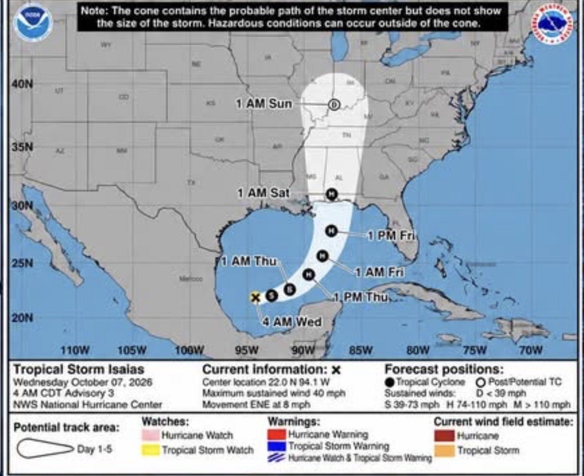
Gov. Ron DeSantis has declared a state of emergency for Holmes and Washington counties as a developing Gulf system strengthened into Tropical Storm Isaias early Wednesday, placing much of Northwest Florida on heightened alert for possible heavy rain, flooding, damaging winds and tornadoes later this week.
DeSantis signed Executive Order 26-202 Tuesday, October 6, declaring a state of emergency in 25 counties across North Florida, including Holmes, Washington, Bay, Jackson, Walton, Okaloosa and several other Panhandle and Big Bend counties. The order allows the state to mobilize personnel, equipment and other resources ahead of the storm.
The declaration does not mean hurricane conditions are certain in Holmes or Washington counties. Instead, it gives state and local agencies additional authority and flexibility to prepare before the storm’s eventual track and impacts become clear.
Emergency management officials in Holmes and Washington counties are preparing for possible impacts from Tropical Storm Isaias as the developing system moves across the Gulf of Mexico, with forecasts indicating the storm could strengthen significantly before approaching the northern Gulf Coast later this week.
According to information released Wednesday morning, October 7, Tropical Storm Isaias had formed in the southwestern Gulf of Mexico with maximum sustained winds of approximately 40 mph and was moving east-northeast at about 8 mph.
Forecast guidance indicates the system could strengthen rapidly over the next several days and potentially become a hurricane as it moves toward the northern Gulf Coast. However, considerable uncertainty remains regarding the storm’s eventual track, intensity and potential point of landfall.
For Holmes and Washington counties, that uncertainty means it remains too early to determine exactly what impacts the area could experience. Depending on the storm’s eventual path, strength and size, potential hazards across the inland Florida Panhandle could include heavy rainfall, localized or flash flooding, strong wind gusts, power outages and isolated tornadoes.
Emergency management officials in both counties are emphasizing that residents should prepare now rather than wait until the storm’s eventual path becomes certain.
Holmes County Emergency Management Director Barry Lee said Wednesday that local officials are already coordinating with state emergency managers and beginning preparations for the possibility of significant impacts.
“We’re monitoring daily and participating in statewide SERT calls twice a day, making preparations via our EM protocols, and starting to pre-position and pre-stage resources,” Lee said.
Lee said officials are preparing for a potentially serious scenario while remaining hopeful that the system ultimately changes course or has minimal impact on Northwest Florida.
“We’re staging for worst-case scenario growth and impact and praying for change of course and no impact, but we’re going to be prepared regardless,” Lee said.
Holmes County has dealt with significant severe weather events in recent years, experiences Lee said have helped local agencies strengthen their response capabilities.
The county’s response to previous tornadoes provided emergency personnel with firsthand experience in disaster response and recovery. Personnel from the Holmes County Sheriff’s Office have also deployed to assist communities elsewhere in Florida following hurricanes Helene and Milton.
Lee said those experiences have left Holmes County considerably better prepared for another major weather event.
“We gained significant education in response and recovery from the Holmes County tornadoes that hit a while back, and sheriff’s office deployments to assist our partners down south during hurricanes Helene and Milton, so we’re 100% better prepared locally than we ever have been,” Lee said.
Holmes County Emergency Management is encouraging residents to review their hurricane plans and emergency kits, secure loose outdoor objects and continue monitoring forecasts as the system develops.
Officials also recommend residents have more than one method of receiving emergency alerts, particularly if power or cellular service is disrupted.
Washington County Emergency Management is delivering a similar message, cautioning residents against becoming overly focused on any single forecast model or projected track while the system continues to develop.
“Now is the time to prepare-not panic,” Washington County Emergency Management stated.
Officials are encouraging residents to make sure they can receive emergency weather information through multiple sources and to review household emergency plans before conditions potentially deteriorate.
“Make sure you have multiple ways to receive weather alerts, review your emergency plan, and stay informed through reliable sources,” the agency stated. “Do not focus on one specific track; the forecast will continue to change as the system develops.”
Washington County Emergency Management said it will continue monitoring the storm and provide additional information to residents as new forecasts and information become available.
“We will continue monitoring Tropical Isaias and will keep our community informed as new information becomes available,” the agency stated. “Stay weather aware. Monitor official forecasts. Be prepared.”
Emergency officials are also reminding residents that the National Hurricane Center’s forecast cone should not be interpreted as the geographical area that will experience impacts.
The cone represents the probable path of the center of the storm. Tropical-storm-force winds, heavy rainfall, tornadoes and other hazards can extend well outside that area, particularly if the system grows in size as it strengthens.
Likewise, small changes in a tropical cyclone’s track can significantly change the impacts experienced by individual communities.
For Holmes and Washington counties, the storm’s ultimate path will be especially important. A track bringing the system closer to the central or eastern Florida Panhandle could increase the potential for stronger winds and heavier rainfall locally, while a farther westward track could reduce some impacts. Even with a landfall outside the immediate area, however, outer rainbands could produce periods of heavy rain, gusty winds and isolated tornadoes.
Officials are therefore urging residents not to base preparation decisions solely on whether their home or community appears inside or outside the center of the current forecast cone.
With the system still developing, officials say the next several days provide residents an opportunity to make basic preparations without panic or last-minute rushing.
Residents should review emergency supplies and ensure they have adequate food, drinking water, necessary medications, flashlights, batteries and other essential items. Phones, portable battery packs and rechargeable devices should be charged before conditions deteriorate.
Loose objects around homes and businesses including patio furniture, decorations, garbage cans and other items capable of becoming airborne, should be secured if the threat to the area increases.
Families should also review how they would communicate if cellular service is interrupted and identify where they would go if severe weather, flooding or other conditions make remaining at home unsafe.
Residents who use generators should ensure equipment is operational but should never operate a generator inside a home, garage or other enclosed or partially enclosed area because of the risk of deadly carbon monoxide poisoning.
Those who depend on electrically powered medical equipment should also consider backup power arrangements and make preparations before outages occur.
Drivers should never attempt to cross flooded roadways. Water covering a road can conceal washouts and other hazards, and even relatively shallow moving water can sweep a vehicle from the roadway.
Residents are also encouraged to check on elderly family members, neighbors and others who may need assistance preparing.
The forecast for Isaias is expected to become clearer as additional information about the storm and surrounding atmospheric conditions becomes available.
Until then, emergency officials in both Holmes and Washington counties are emphasizing readiness rather than speculation over precisely where the storm will eventually make landfall.
Residents should rely on information from the National Hurricane Center, National Weather Service, Florida Division of Emergency Management and their respective county emergency management agencies rather than unofficial forecast graphics or individual computer models circulating on social media.
Holmes County residents can also register for local emergency notifications through AlertHolmes.
For now, the message from emergency managers across the two counties remains consistent: stay informed, prepare for the possibility of impacts and remain weather aware as Isaias moves across the Gulf.
 Staff Report
  AMBER PATINO